


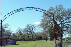
New Church Cemetery
Click on photo to enlarge and for additional photo
Photos courtesy of Henry and Nancy Hanson
Cemetery Name: |
New Church |
Location: |
Edge |
County: |
Brazos |
USGS Quad: |
Edge |
Coordinates: |
30°54'29"N / 96°17'0"W |
Maintained by: |
Unknown |
Land owner: |
Unknown |
Read by: |
Nancy and Henry Hanson |
Date read: |
September 2005 |
| Photos by: | Henry and Nancy Hanson |
Date added to Rambler web site: |
May 2006 |
Condition of cemetery**: |
Excellent |
Comments: |
Corgey Cemetery no longer exists. All persons interred in the Corgey Cemetery were moved to the New Church Cemetery in Edge. |
Directions: |
From intersection of Hwy 6/East Bypass and TX 21/US 190 go northeast on Hwy 21/190 for 14.1 mi. to FM 974/Tabor Rd. Go left on FM 974/Tabor Rd for 5.8 mi. to Macey Rd. Go right on Macey Rd. for 0.8 mi. to New Church Cemetery Rd. Go left at New Church Cemetery Rd for 0.4 mi. Cemetery will be straight ahead. |
** Condition of
cemetery as observed on the given date -
may not be representative of care at other times of the year
Scale: Excellent - Good - Fair - Poor - Abandoned
*Explanation
of Abbreviations:
R = Right side of road; L = Left side of road; BC =
Back center; C = Center
d/s = double stone; t/s = triple stone; q/s quadruple stone
s/o = son of ; d/o = daughter of; c/o = child of; m/o = mother of; h/o = husband of; w/o =
wife of;
FS = Footstone; FHM = Funeral Home Marker; MM = Military Marker; SRC - Source; BCGS = Brazos County Genealogical Society; BCGSQ = Brazos County Genealogical Society Quarterly; TDR = Texas Death Records; SSDI = Social Security Death Index; WOW = Woodman of the World